It’s also the only continent without a southern coast.
Science Memes
Welcome to c/science_memes @ Mander.xyz!
A place for majestic STEMLORD peacocking, as well as memes about the realities of working in a lab.

Rules
- Don't throw mud. Behave like an intellectual and remember the human.
- Keep it rooted (on topic).
- No spam.
- Infographics welcome, get schooled.
This is a science community. We use the Dawkins definition of meme.
Research Committee
Other Mander Communities
Science and Research
Biology and Life Sciences
- !abiogenesis@mander.xyz
- !animal-behavior@mander.xyz
- !anthropology@mander.xyz
- !arachnology@mander.xyz
- !balconygardening@slrpnk.net
- !biodiversity@mander.xyz
- !biology@mander.xyz
- !biophysics@mander.xyz
- !botany@mander.xyz
- !ecology@mander.xyz
- !entomology@mander.xyz
- !fermentation@mander.xyz
- !herpetology@mander.xyz
- !houseplants@mander.xyz
- !medicine@mander.xyz
- !microscopy@mander.xyz
- !mycology@mander.xyz
- !nudibranchs@mander.xyz
- !nutrition@mander.xyz
- !palaeoecology@mander.xyz
- !palaeontology@mander.xyz
- !photosynthesis@mander.xyz
- !plantid@mander.xyz
- !plants@mander.xyz
- !reptiles and amphibians@mander.xyz
Physical Sciences
- !astronomy@mander.xyz
- !chemistry@mander.xyz
- !earthscience@mander.xyz
- !geography@mander.xyz
- !geospatial@mander.xyz
- !nuclear@mander.xyz
- !physics@mander.xyz
- !quantum-computing@mander.xyz
- !spectroscopy@mander.xyz
Humanities and Social Sciences
Practical and Applied Sciences
- !exercise-and sports-science@mander.xyz
- !gardening@mander.xyz
- !self sufficiency@mander.xyz
- !soilscience@slrpnk.net
- !terrariums@mander.xyz
- !timelapse@mander.xyz
Memes
Miscellaneous
For now. It used to a few million years ago and will again in another few million.
Are you referring to the magnetic pole switch? That happens every 200-1M years, according to patterns on the seafloor. It’s been estimated that the last reversal was 780,000 years ago, so it theoretically could be any day now.
With that being said, I doubt that humanity will agree to turn all maps 180° to correspond.
I thought they were referring to the fact that under the ice its an archipelago, so if the ice melts it will have southern coasts again
Valid point. It’s a shame humanity wouldn’t be around to confirm. lol
I was referring to continental drift. Places move a lot in under 200 million years. Eg https://youtu.be/uLahVJNnoZ4
So my post was a bit sarcastic that eventually it will have a coast but not on any time frame to matter to the human species. :)
Laschamp event! I just edited a related wiki page on late Pleistocene extinctions. Spoiler alert: it didn't kill the megafauna.
Yeah, because you'll fall off the bottom into space
Long Earth theory.
How am I supposed to know how big that is? I don't see a banana anywhere....
it's too cold steel wool they don't have bananas
Where Saddam
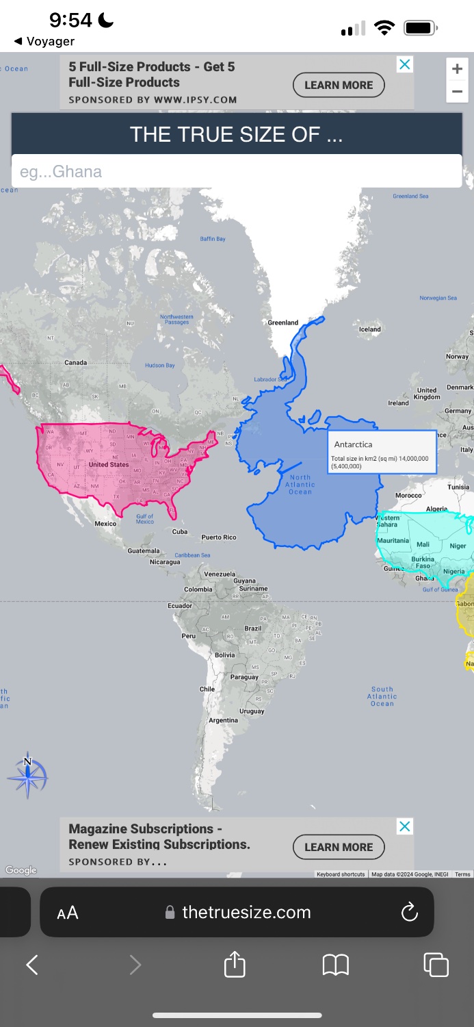
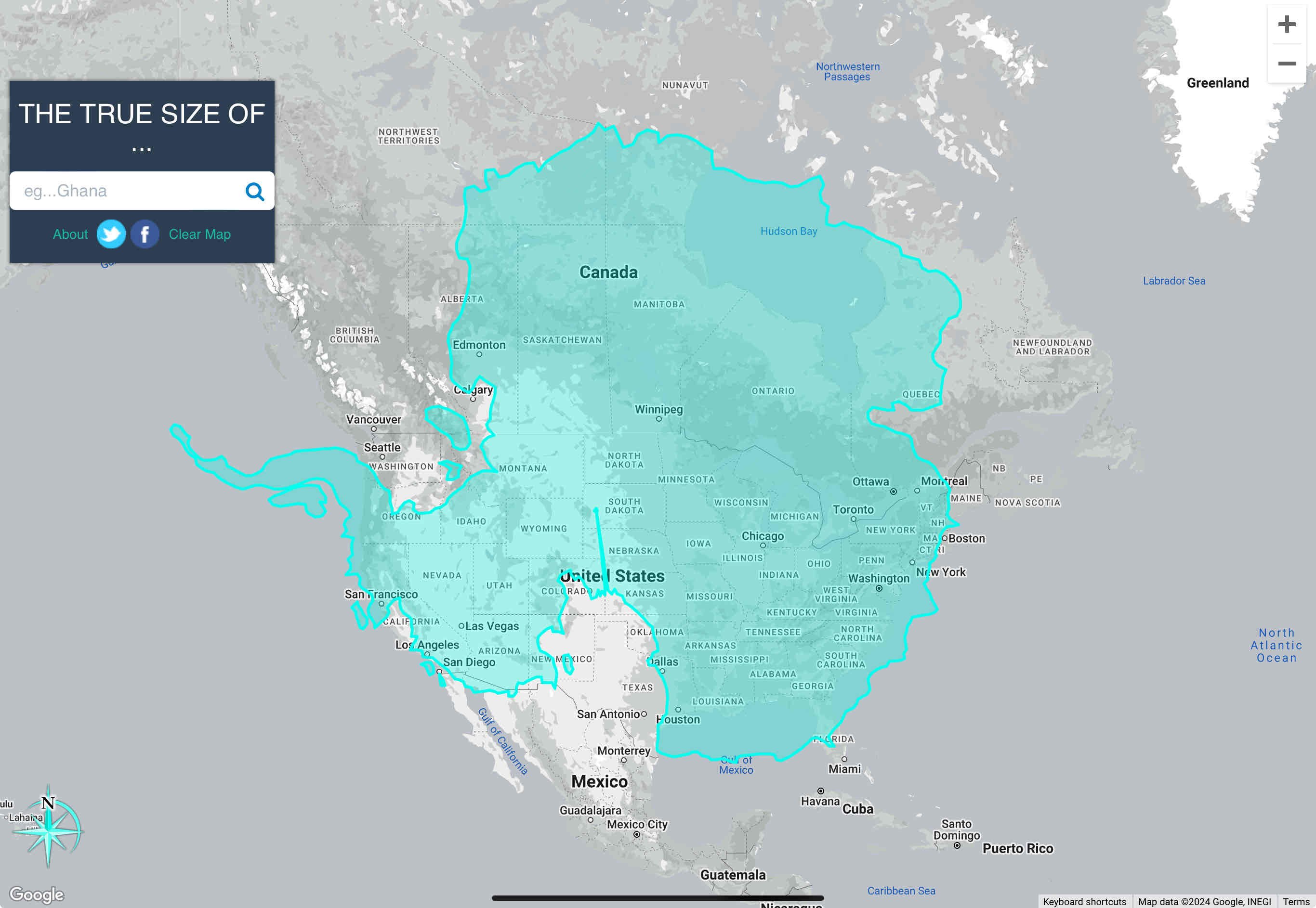
Uh, antartica is about as wide as the U.S. and about as tall as it is wide.
So, I just feel like I’m being bamboozled here
Mercator maps are lies.
https://www.thetruesize.com/#?borders=1~!MTY2MDE2NDA.NDc5Njc5NwMjE1MTM3Mjc(MzM1MDIwMDg~!AQMTczNjE5MDg.MTI2ODc2MjY)MA
Yeah, they certainly are:

That is inaccurate. The correct way to use the tool is to lay the continent over the US. It skews the size and scale appropriately in order to provide an accurate measurement.

It’s also larger in area than the US, including Alaska and all territories.
The total area of the US and its territories is just over 3.8 million square miles. Antarctica's area of 5.4 million square miles makes it 1.5x the size of the US.
The correct way to use the tool is to lay the continent over the US.
Typical American, declaring that the US is the default country to compare every other country to!
On a more serious note, putting things side by side is the same as putting them over each other. Difference in height are not the same though, as closer to the equator size shrinks. The best way to compare is take two things and put them side by side on the equator - that's where there's least distortion.

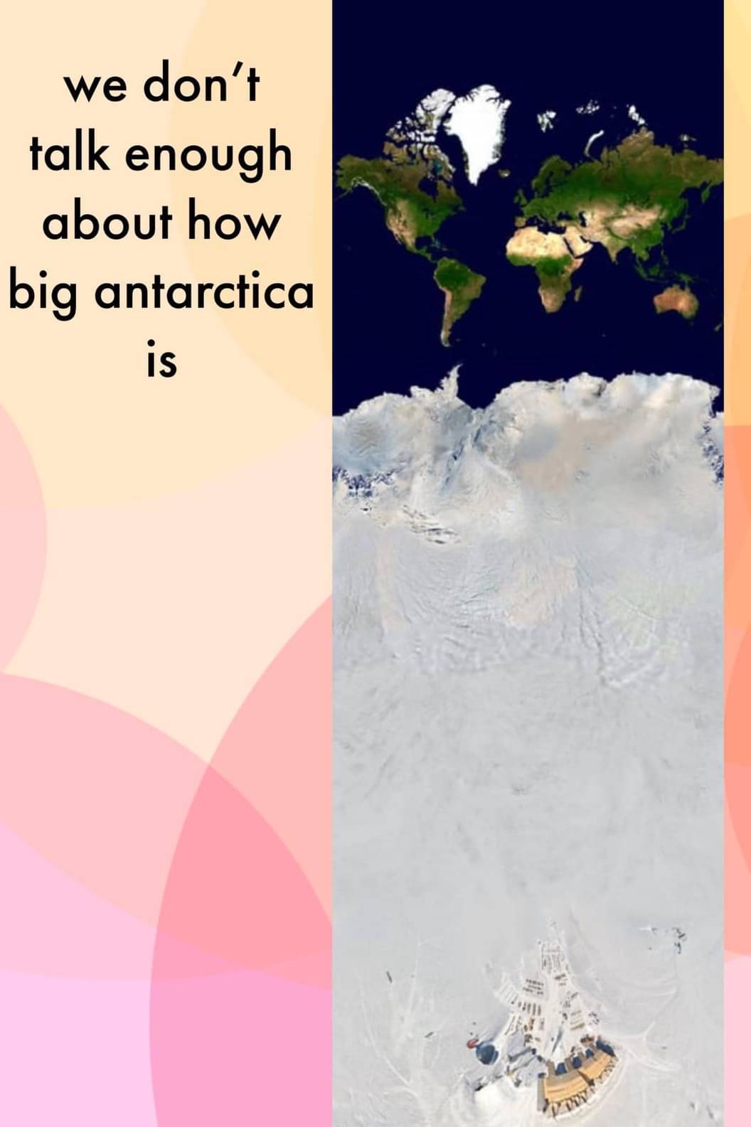
Just look at the map, what more proof do you need?
Yeah it's definitely not a real projection. If Antarctica looked like that (taken top down) then the rest of the continents would not be oriented like that.
and we certainly wont be in a few hundred years lmao.
Big if true
Wait what? Did we just find Hitler's secret Antarctica base?
That’s the Amundsen–Scott South Pole Station.
Nonsense! Did you see how big that thing is? Definitely Hitler!
According to this projection, it's bigger than Africa
Can we talk about how big that structure is?
About three times the size of Europe it seems, one hell of a building.
Ok, but that's unironically a great map for a TTRPG campaign.
I'm thinking Lovecraft. Plateau of Leng and all that. There's just this huge, impassable land that goes south for what seems like forever. And...things...occasionally wander out of it.
My country holds a claim and permanent population to a portion of antartica.
Many have "claims". None are valid though.
How many flags are planted? No flag, no Antarctica. Those are the rules that I just made up.
Yeah but the permanent population is there, sakd claim precedes the treaty.
No bears, tho.
And getting smaller everyday
Serious Q: isn't there actually a lot resources in Antarctica? Or is it just too difficult to set up shop there?
There certainly are, but...
https://en.m.wikipedia.org/wiki/Antarctic_Treaty_System
This treaty means the entire continent is for science only.
When you say resources what resources are you referring to specifically?
Penguin leather
Cool band name
They do punk songs about Linux.
