this post was submitted on 29 Dec 2023
45 points (100.0% liked)

OpenStreetMap community

4181 readers
33 users here now

Everything #OpenStreetMap related is welcome: software releases, showing of your work, questions about how to tag something, as long as it has to do with OpenStreetMap or OpenStreetMap-related software.

OpenStreetMap is a map of the world, created by people like you and free to use under an open license.

Join OpenStreetMap and start mapping: https://www.openstreetmap.org/.

There are many communication channels about OSM, many organized around a certain country or region. Discover them on https://openstreetmap.community/

https://mapcomplete.org/ is an easy-to-use website to view, edit and add points (such as shops, restaurants and others)

https://learnosm.org/en/ has a lot of information for beginners too.

founded 4 years ago
MODERATORS
 

I was updating my old high school on OSM and noticed that whoever mapped it before used a multipolygon to map the buildings. From what I can tell the benefit to this is that you can map more complex shapes by having them be related, is that correct?^2^

There are some buildings that have been added as building=yes instead of building=school (some haven't been marked at all) and I want to make sure I understand it better before I go and make any big changes.

^1^ my old high school for context - Esri World Imagery has the best image quality once you zoom in.
^2^ My understanding comes from this wiki page

EDIT:
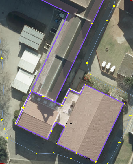
Some extra clarification as to why I'm asking. There are some buildings that have been added as separate multipolygons which don't make sense to me. (see screenshot), these two buildings were added as separate multipolygons but they are connected and form part of the same building.

I also get a warning in JOSM that says "amenity inside amenity - amenity=school inside amenity=school"
top 7 comments
sorted by: hot top controversial new old
[–] infeeeee@mastodon.social 17 points 10 months ago (1 children)

@governorkeagan you have to use a multipolygon if the building has "holes", e.g. interior gardens or similar things, there is simply no other way. I can see this is the case with your school.

About building=yes, that's the default. Usually you can't decide the type and usage of a building from aerial imagery, so you should just use 'yes' in that case. If you know the building you should fix its type.

[–] governorkeagan@lemdro.id 6 points 10 months ago (1 children)

Thanks for confirming that for me!

[–] infeeeee@mastodon.social 2 points 10 months ago (1 children)

@governorkeagan about your edit: that building should be part of the big building not separate. If you want to differentiate parts of the building you can use building:parts or indoor mapping. https://wiki.openstreetmap.org/wiki/Key:building:part https://wiki.openstreetmap.org/wiki/Simple_Indoor_Tagging

About the error: you should tag the school as an area OR as a node, not both. There is a detailed sectiom about this in the wiki, check the image in the section "How to map" https://wiki.openstreetmap.org/wiki/Tag:amenity%3Dschool

[–] governorkeagan@lemdro.id 1 points 10 months ago

That’s what I thought, I’ve made some changes in JOSM that fixes the error (tagged the school as an area). Thanks again for the help!

[–] breakcore@discuss.tchncs.de 5 points 10 months ago

Thanks for making the map better and thanks for asking questions! 🤗

[–] bbbhltz@beehaw.org 4 points 10 months ago (1 children)

I work at a university (grande école) where the buildings are mapped like this. Despite being one large structure, it was not always the case. Building A and C were built in the 90s, building B in the early 2000s was built to connect them. We still use the different building names today and have A through H. D is a castle and F was only added last year, even though G and H are nearly as old as A and C. I feel bad for the amphitheatre being left out of the lettered naming scheme... Poor "AMPHI".

Perhaps your school was built building by building so they just added a new polygon instead of redrawing it.

Should I go change my school's buildings too?

[–] governorkeagan@lemdro.id 1 points 10 months ago

I’m 99% sure that the building you see in my post was added after the original building. It’s all been built as one big building now though.

What I’ve done in some areas (after making it all one big building) is to add specific names/details as building:part=yes but not for everything