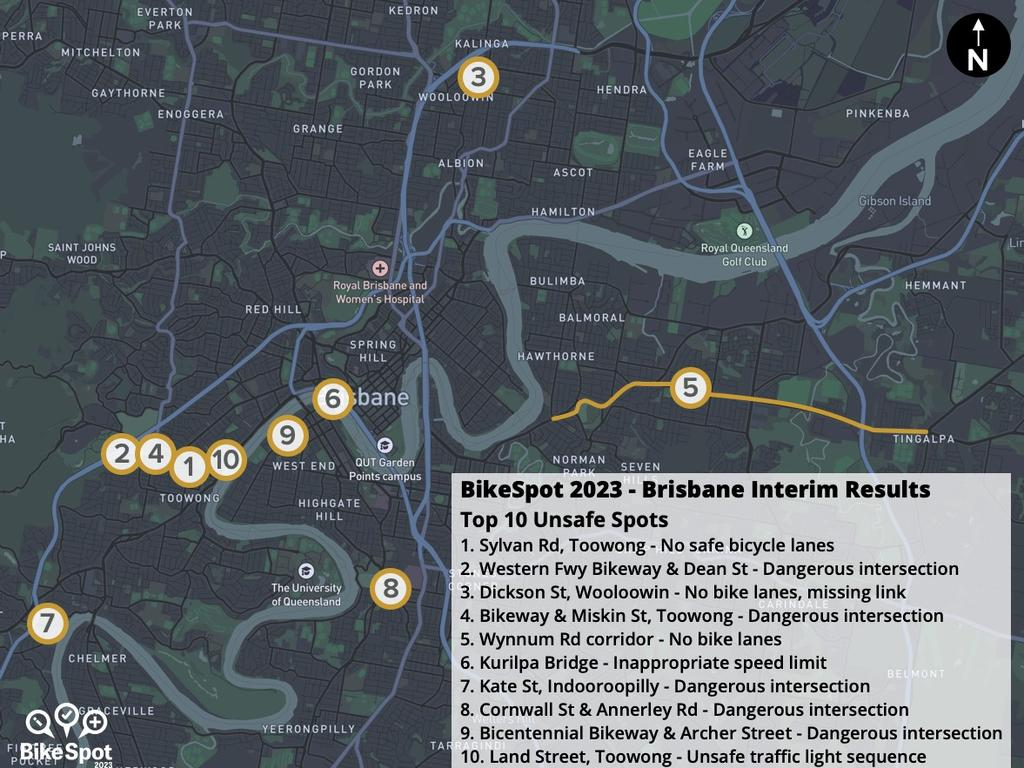
The 10 most dangerous Brisbane roads for cyclists have been mapped on a new app, with an inner-city road notorious for a lack of safe bicycle lanes taking out top spot.
Thousands of cyclists and drivers have pinpointed Brisbane’s most unsafe roads, with the top ten dangerous hotspots made public on a new interactive bike map app.
The BikeSpot app, which was initially launched in Victoria, has now been made Australia-wide to give community feedback straight to local councils to influence future infrastructure projects.
Since October, more than 4000 Queenslanders have voted which Brisbane bikeways and roads they deem most unsafe for cyclists and drivers, with several spots identified in Toowong, including two intersections along the Western Freeway Bikeway.
Sylvan Rd in Toowong was voted most dangerous due to a lack of safe bicycle lanes, followed by the intersection at Western Freeway Bikeway and Dean St.
Dickson St at Wooloowin came in third, and the intersection at Western Freeway Bikeway and Miskin St in Toowong, fourth.

The Kurilpa Bridge was also labelled dangerously unsafe due to inappropriate speed limits, while an unsafe traffic light sequence on Land St in Toowong was found to put travellers at risk.
Also on the list were Wynnum Rd corridor which has no bike lanes, and dangerous intersections at Kate St and Witton Rd, Indooroopilly and Cornwall St and Annerley Rd, Annerley.
The BikeSpot map was created following the death of cyclist Amy Gillett in 2005. Users are invited to drop pins on locations that they think are either great riding spots, or areas in need of improvement, such as narrow lanes, high traffic speed, or missing connections.
Amy Gillett Foundation chief executive Dan Kneipp said at lot of tension between drivers and cyclists stemmed from “bad road design” and the app data provided a unique opportunity for Brisbane City Council to hear from residents before hosting the Olympic and Paralympic Games.
“We want to work with local government and show them the data and help them fix local bike routes,” he said.
“Brisbane has this phenomenal opportunity to create safer bike lanes, reduce congestion and have a legacy item post 2032.”’
The Bicentennial Bikeway, Veloway 1 and CityLink cycleways and Indooroopilly Riverwalk path were all voted as the safest spots for travel.
Brisbane mother Karla Vaughan said while bikeways were becoming safer, mixed-used footpaths remained “pretty crazy” during peak hour.
“Pedestrians, strollers, bikes, electric scooters are all using them,” she said.
“But we are starting to see more defined bike paths around the suburbs and city now, which is great and so much safer.”
BikeSpot is of the Australian Government’s Safe Roads for Safe Cycling Program.
Brisbane’s worst bike spots
- Sylvan Rd, Toowong – No safe bicycle lanes
- Western Freeway Bikeway and Dean St, Toowong – Dangerous intersection
- Dickson St, Wooloowin – No bike lanes and missing link
- Western Freeway Bikeway and Miskin St, Toowong – Dangerous intersection
- Wynnum Rd corridor – No bike lanes and missing link
- Kurilpa Bridge – Inappropriate speed limit
- Kate St and Witton Rd, Indooroopilly – Dangerous intersection
- Cornwall St and Annerley Rd, Annerley – Dangerous intersection
- Bicentennial Bikeway and Archer St – Dangerous intersection
- Land St, Toowong – Unsafe traffic light sequence
