OpenStreetMap community

4181 readers
33 users here now

Everything #OpenStreetMap related is welcome: software releases, showing of your work, questions about how to tag something, as long as it has to do with OpenStreetMap or OpenStreetMap-related software.

OpenStreetMap is a map of the world, created by people like you and free to use under an open license.

Join OpenStreetMap and start mapping: https://www.openstreetmap.org/.

There are many communication channels about OSM, many organized around a certain country or region. Discover them on https://openstreetmap.community/

https://mapcomplete.org/ is an easy-to-use website to view, edit and add points (such as shops, restaurants and others)

https://learnosm.org/en/ has a lot of information for beginners too.

founded 4 years ago
MODERATORS
126
127


Not clear yet what the concrete benefits are, but it’s worth noting #OpenStreetMap has been registered as a “Digital Public Good” by the Digital Public Goods Alliance (#DPGA), which is a multi-stakeholder United Nations-endorsed initiative.
https://blog.openstreetmap.org/2024/02/05/osm-named-as-a-digital-public-good-by-un-affiliated-agency/

#UN #UnitedNations cc: @openstreetmap

128


Unfortunately the OSM website has a limit to how many it can show you at once and it shows the most recently updated ones, so you can't see how many unclosed notes still exist.

One of them is over five years old and requires on-site verification, so I know what I'm doing this weekend!

129
130


I don't see an option to enter that info on StreetComplete or EveryDoor, and it would be hard to open your laptop every time

This was specific to a university campus, to try and map out the amenities available to the public / to students

131


A nearby city call these crossings as "Gora¹ Lanes", an attempt to make walking fun, attractive, and accessible to more people.

From the screenshot² below, it's something like an arty zebra (or "continental") crossing, and I saw minimal use of crossing:markings=artwork in #OpenStreetMap, and taggable with crossing:markings=yes.

I wonder how you folks might tag it.

¹ - Gora is an acronym from "Green Open Reclaimed Access"
² - Source: screenshot, https://yewtu.be/lKMFjLcTVkQ?t=59

@openstreetmap

132


When mapping street addresses in #OpenStreetMap, the minimum tag you probably need is addr:housenumber and addr:street, or maybe addr:place.

In this example, house numbers 971 and 977 are the only two points actually mapped, and connected by a way tagged with addr:interpolation=odd.

The geocoder still returned the estimated position for the unmapped housenumber, 975.

Read about interpolation here: https://osm.org/wiki/Addresses#Interpolation

It's a quick method for adding street addresses in @openstreetmap

133


Have you been receiving unsolicited messages in your #OpenStreetMap inbox?

Well, it seems like this feature has been quietly introduced recently: "mute this user" link is now available for every @openstreetmap user page.

134


Apart from the @vespucci_editor and @osmandapp , do you know of any other mobile #OpenStreetMap editor that supports custom tile layers?

@openstreetmap

135


When editing #OpenStreetMap on the go, @everydoor is my hands-down favorite, but I'd hesitate recommending it for more new mappers.

I've been playing with #OsmGo just now, and really like how easy it is, maybe even for new contributors.

Plus, it's a progressive web app that runs in a browser, or installable in your device: https://osmgo.com , so this also seems to be a great candidate tool to introduce as a friendly editor for @openstreetmap mapping parties for new users.

136


Here is their pull request (with plenty of users negative comments)

They even got anti-feature from F-Droid because of this

If short, developers don’t listen to users opinions and just close all (or nearly all) issues with negative comments about this.

Not to overflood topic I will post links to closed issues in “code” box. This is the list where users are really unhappy about this idea:

https://github.com/organicmaps/organicmaps/issues/7119
https://github.com/organicmaps/organicmaps/issues/6707
https://github.com/organicmaps/organicmaps/issues/6773
https://github.com/organicmaps/organicmaps/issues/6668
https://github.com/organicmaps/organicmaps/issues/6967
https://github.com/organicmaps/organicmaps/issues/6774
https://github.com/organicmaps/organicmaps/pull/6720
https://github.com/organicmaps/organicmaps/issues/6774

From kayak privacy policy (kayak[dot]de/privacy (not clickable not to make you accidentally leak your information to them)):

What they STEAL:

- Personal details (such as your name, age, birthday, gender)
- Contact information (such as email address, address, phone number)
- Booking information (such as, for each traveler, the traveler's name, frequent flyer details, passport number, redress control number, country of citizenship, booking reference number, and itinerary, which may include name of airline or carrier, hotel accommodation and/or vessel, port of destination, port of arrival, date and time of departure and/or check-in, date and time of arrival and/or check-out, meal preferences, luggage information, and layover information)
- Account information (such as login credentials, including email address and password, and account settings)
- Social media data (if you choose to link your KAYAK account with a social media account, KAYAK may collect personal information such as name, age, gender, photograph, and other personal information relating to your social media account)
- Billing information (such as credit, debit, or other payment card information and billing address)
- Your contacts (such as contact information of people you add to, or notify of, your reservations or itineraries through our Services)
- Your preferences (such as your home airport, seating preferences, meal preferences, communication preferences, and other preference information you provide us)
- Reviews you submit (including any screenname you publish under or any personal information you include about yourself or others in such review)
- Content you publish (including your travel recommendations and any personal information you include about yourself or others, or in content you publish in your Guide or other mediums provided by us)
- Photos of you (such as when you add a photo of yourself to your profile, upload photos to a review, or link your social media account to your KAYAK account)
- Communications you send us (such as questions, conversations, complaints, or other information that you may submit to our support team)
- Promotion information (if you choose to participate in a contest, sweepstakes, or similar campaign, we will collect any information you provide in relation to such activity, such as photos, images, captions, or other content, in accordance with the terms provided at that time)
- Other information you may provide (including other information you provide about yourself or others through our Services or to which you provide us with access via third-party platforms)

What they can do with this:

- Send you marketing communications, including communicating with you about services or products offered by KAYAK, our group companies, or our business partners…
- Provide services and information to travel partners, such as providing user feedback and usage details
- Provide you more relevant advertising on and off our Services
- Comply with our policies, procedures and legal obligations, including complying with law enforcement or government authority requests
- As otherwise consented to by you and as required or permitted by applicable law

The most important thing is that, that developers argue with F-Droid community, their own community, and closing everything that related this idea.

137


This can save you some time when opening the OSM Website.

Also links to coordinates or objects can be shortened like https://osm.org/relation/62422

Unfortunately Mozilla-based browsers do not save the osm.org in history.

138
 
 
139


If you're an #OpenStreetMap contributor, and active in the #Fediverse, where do you check for unexpected downtimes?

You can follow the OSM Ops Team: @osm_tech for technical updates.

@openstreetmap

140


This project has its own enforced policy: its purpose is a pure artistic creation project (or game with its rules) which forbids using any data representing real object on Earth. Even the displayed names must be invented.

The map is in constant evolution (work in progress), it may evolve over time more rapidly and more dramatically than what occurs on real Earth. It has its own imaginary local events similar to what exists on Earth: hurricanes, floodings, volcanoes, political events, dictatures or democratic processes; islands or continents may appear suddenly or disappear completely; cities may be destroyed or replanned completely differently by their authors in their approved area of work; shipping lines or roads may appear or disappear, a previously dry desert could become a rain forest...

141


Basically, I'm making a lot of progress drawing in buildings and upgrading sidewalks to modern standards in my city, but sometimes I lose track of what I have and haven't done yet. As simple as highlighting the areas I've finished in a colour, is there a way I could track this? I'm willing to use any kind of tool for the job.

142


I’ve been using Magic Earth on my phone for the last little while and have been really happy with it (I have Organic Maps and OsmAnd installed as well). I haven’t found anything good for desktop that includes public transport navigation (my primary use case).

143


🌟 mapilio.com Updated! 🎉

Hello Mapilio Community!
We're excited to announce an update to Mapilio.com! Now, a sleek and user-friendly experience awaits you with the addition of a dark theme option.

🌙 Dark Theme Enabled!
Explore our maps in a dark theme by visiting: www.mapilio.com/app

Thank you and enjoy your map exploration!

Mapilio Team 🗺️✨

#mapilio #OpenStreetMap #OSM #map #mapping #GIS #AI #update @openstreetmap @openstreetmap@lemmy.ml @openstreetmapus @mapilio

144
45
submitted 10 months ago* (last edited 10 months ago) by governorkeagan@lemdro.id to c/openstreetmap@lemmy.ml


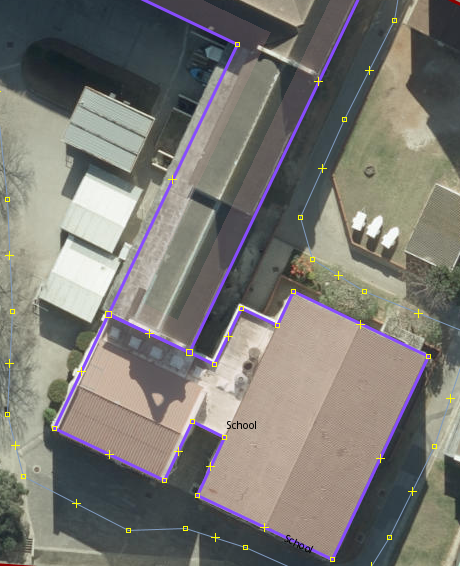
I was updating my old high school on OSM and noticed that whoever mapped it before used a multipolygon to map the buildings. From what I can tell the benefit to this is that you can map more complex shapes by having them be related, is that correct?^2^

There are some buildings that have been added as building=yes instead of building=school (some haven't been marked at all) and I want to make sure I understand it better before I go and make any big changes.

^1^ my old high school for context - Esri World Imagery has the best image quality once you zoom in.
^2^ My understanding comes from this wiki page

EDIT:
Some extra clarification as to why I'm asking. There are some buildings that have been added as separate multipolygons which don't make sense to me. (see screenshot), these two buildings were added as separate multipolygons but they are connected and form part of the same building.

I also get a warning in JOSM that says "amenity inside amenity - amenity=school inside amenity=school"

145


Is there an easy way to update multiple buildings with the same street name?

I’m mapping an area from my old neighbourhood/city that doesn’t have most of the buildings mapped. For now, I’m just trying to get the buildings added, I’m not super worried about adding addresses at the moment.

SOLUTION
Using the ID Editor, hold SHIFT and select the buildings.

146
25
submitted 10 months ago* (last edited 10 months ago) by Masimatutu@mander.xyz to c/openstreetmap@lemmy.ml
147
148
149


Does anyone here have a phone/device just for mapping? A lot of the mapping I’m doing now is updating details of already mapped items.

I was thinking of getting a cheap secondhand android phone to use just for mapping. I’d also love to use StreetComplete again!

150
 
 
view more: ‹ prev next ›